📑 Table of Contents
- • Introduction
- • Detailed Theory (with Sub Heading)
- ↳ 1. Physiographic Divisions of India: An Overview
- ↳ 2. Important Rivers and their Notorious Nicknames
- ↳ 3. The Crown Jewels: Highest Peaks of the World and India
- ↳ 4. The Northern Mountain Region (The Himalayas)
- ↳ 5. Theories of the Origin of the Himalayas
- ↳ 6. Sub-Divisions of the Northern Mountain Region
- • Short Tricks for Quick Memorization
- • Mind Map
- • 20 One-liner Questions and Answers
Introduction
Hello friends, future officers and dedicated aspirants! Welcome to this comprehensive and specially crafted study guide. If you are preparing for competitive exams like UPSC, State PSCs, SSC, NDA, or Railways, you already know that Indian Geography is a highly scoring and foundational subject. Today, we are going to dive deep into one of the most fascinating chapters of this subject: The Physiographic Divisions of India and, specifically, the majestic Northern Mountain Region.
Geography is not just about memorizing random facts, latitudes, or longitudes from a textbook. It is the beautiful science of understanding our Earth's canvas! When we talk about India, it isn't just a country; it's an entire subcontinent brimming with incredible geographical diversity. Have you ever wondered how the mighty Himalayas—the tallest mountains on Earth—were formed? Or did you know that despite having these towering peaks, the largest portion of India's landmass is actually flat plains?
In these detailed study notes, we will unravel the story of India's physical formation. We will break down complex geological theories into simple, story-like explanations. Designed with a "human touch" to feel like a personal mentoring session, these notes are optimized to help you understand the concepts deeply and crack those tricky exam questions with ease. So, grab a cup of coffee, keep your atlas open, and let's embark on this wonderful geographical journey!
Detailed Theory (with Sub Heading)
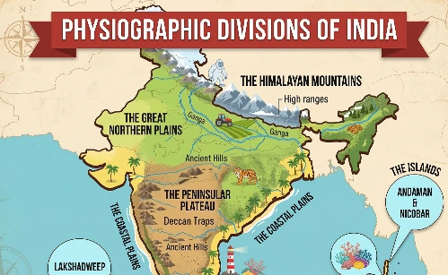
1. Physiographic Divisions of India: An Overview
The geological structure of India is incredibly diverse. Over millions of years, tectonic movements, volcanic eruptions, and the continuous flow of rivers have sculpted the Indian landmass into its current form. Because of this rich geological history, India possesses a wide variety of relief features (the highs and lows of the Earth's surface).
Percentage Distribution of India's Landforms: Examiners frequently ask about the exact percentage of land covered by different relief features. Here is how India's total geographical area is distributed:
-
Plains (43.2%): The largest portion of our country is flat. This is the backbone of our agrarian economy, providing highly fertile soil for agriculture.
-
Plateaus (27.7%): These are elevated, flat-topped tablelands, rich in mineral resources (like the Deccan Plateau).
-
Hills (18.6%): Elevated areas that are lower and less steep than mountains.
-
Mountains (10.5%): The towering, steep peaks, including the mighty Himalayas.
Teacher's Tip: Always remember this descending order based on area: Plains > Plateaus > Hills > Mountains. It’s a common sequence question in preliminary exams!
The Six Major Physiographic Divisions
Based on relief features, tectonic history, and physical characteristics, India is officially classified into 6 Physiographic Divisions:
-
Northern Mountain Region (The Himalayas and Trans-Himalayas)
-
Northern Plain Region (The Indo-Gangetic-Brahmaputra plains)
-
Peninsular Plateau Region (The oldest landmass of India)
-
Coastal Plain Region (Eastern and Western coasts)
-
Island Group Region (Andaman & Nicobar, and Lakshadweep)
-
North-Western Desert Region (The Thar Desert)
(Note: Some geographers and older NCERT editions group the desert with the plains, and the islands with the coasts, classifying India into 4 broader Natural Regions. However, the 6-division model is standard for modern competitive exams).
2. Important Rivers and their Notorious Nicknames
While studying physical geography, we often come across rivers that have profoundly impacted human settlements, sometimes disastrously. Here are a few direct one-liner facts that frequently appear in exams:
-
Sorrow of Bengal: Damodar River. Historically, this river caused devastating floods in the plains of West Bengal during the monsoons.
-
Sorrow of Bihar: Koshi River. This river is infamous for constantly shifting its course and causing massive, unpredictable floods.
-
The Treacherous River: Hooghly River. Known for its complex and shifting underwater sandbars, making navigation tricky.
-
Karnali River (Ghaghara River): This is a fascinating trans-boundary river. In Nepal, it is known as the Karnali River. But the moment it crosses the border and enters India, it is renamed and known as the Ghaghara River.
3. The Crown Jewels: Highest Peaks of the World and India
When discussing mountains, we absolutely must talk about the highest peaks. This area is a goldmine for objective-type questions.
A. Mount Everest (The Roof of the World):
-
It is the highest mountain peak on Earth.
-
Its officially recognized height is 8848 meters (or 8848.86m / 8849m based on recent joint surveys by Nepal and China), roughly 29,032 feet.
-
The first humans to successfully summit Mount Everest were Edmund Hillary (a mountaineer from New Zealand) and his Tibetan-Nepalese Sherpa guide, Tenzing Norgay. They achieved this historic feat in 1953.
-
Regional Names (Crucial for Exams):
-
In Sanskrit and Nepali: Sagarmatha (Meaning: Goddess of the Sky).
-
In Tibetan: Chomolungma (Meaning: Holy Mother of the Universe).
-
In Chinese: Qomolangma Feng.
-
B. Other Global Giants:
-
Second Highest Peak: K2 (Godwin-Austen). It is located in the Karakoram Range in Pakistan-Occupied Kashmir (POK).
-
Third Highest Peak: Kangchenjunga. It is located on the border of Nepal and the Indian state of Sikkim.
C. Clearing the Confusion: India's Highest Peaks Examiners love to trick students with the wording of these questions. Let's make it crystal clear:
-
Highest Peak of India: K2 (Godwin-Austen). Since India claims POK as its integral territory, K2 is officially India's highest peak.
-
Highest Peak of Undisputed India: Kangchenjunga (Sikkim).
-
Highest Peak located entirely within India: Nanda Devi (Uttarakhand). While Kangchenjunga is shared with Nepal, Nanda Devi lies completely within Indian borders.
4. The Northern Mountain Region (The Himalayas)
Standing like an impenetrable fortress in the north, this region is primarily dominated by the Himalayan mountain range.
-
Geographical Extension: The Northern Mountain Region stretches across a longitudinal extension of about 22°, covering a massive area of approximately 5 Lakh Square Kilometers.
-
Geological Age: The Himalayas were formed during the Tertiary Period of the Earth's geological history.
-
Type of Mountain: Unlike the ancient Aravallis, the Himalayas are Young Fold Mountains. They are called "young" because they were formed relatively recently in Earth's timeline, and they are still growing taller today!
-
Source of Life: This mountainous region is home to massive glaciers (like Gangotri, Yamunotri, and Siachen). The melting snow from these glaciers feeds the perennial (year-round) rivers of Northern India, sustaining millions of lives.
5. Theories of the Origin of the Himalayas
How did such a massive mountain range suddenly appear on the Earth's surface? Geologists have proposed several theories, but two are most prominent for your exams:
-
Geosyncline Theory by Kober
-
Plate Tectonic Theory
(In today's class, we will focus deeply on Kober's fascinating theory).
The Geosyncline Theory by Kober
Kober, a renowned German geologist, proposed a very logical and story-like theory for mountain formation.
-
He famously stated that "Geosynclines are the cradle of mountains." (A cradle is where a baby is born and nurtured).
-
What is a Geosyncline? It is a long, narrow, and shallow water body or sea depression.
-
According to Kober, these water bodies are flanked on both sides by rigid, ancient landmasses known as Forelands.
Step-by-Step Formation of the Himalayas (Kober's View):
-
The Tethys Sea: Around 70 million years ago, where the mighty Himalayas stand today, there was a vast, shallow sea called the Tethys Geosyncline (or Tethys Sea).
-
The Forelands: On either side of the Tethys Sea were two massive, rigid supercontinents. To the north was Angaraland (Laurasia), and to the south was Gondwanaland (which included the Indian landmass).
-
Deposition of Sediments: For millions of years, rivers flowing from Angaraland and Gondwanaland emptied into the Tethys Sea. They brought with them immense amounts of sand, silt, mud, and rocks (sediments), continuously depositing them on the sea floor.
-
Subsidence and Compressional Force: As millions of tons of sediments piled up, their immense weight caused the bed of the Tethys Sea to sink or subside. As the sea floor sank, the two rigid landmasses (Angaraland and Gondwanaland) began to move closer to each other, exerting a massive squeezing pressure known as Compressional Force.
-
The Folding Process: Imagine pushing a layered piece of cloth from both sides; it folds and rises upwards. Similarly, the compressional force squeezed the soft sediments trapped in the Tethys Sea, causing them to fold, crumple, and rise dramatically.
-
Birth of the Mountains: This massive folding of sediments gave birth to the Himalayas in the south and the Kunlun Shan mountains in the north (China).
-
The Tibetan Plateau: The middle portion of the Tethys sediments, which did not fold upward as dramatically, remained relatively flat but was elevated, forming the "Roof of the World"—the Tibetan Plateau.
6. Sub-Divisions of the Northern Mountain Region
For systematic study, geographers divide the Himalayas into two distinct classifications:
-
Geographical Division: Based on physical ranges from North to South (Trans-Himalaya, Greater Himalaya, Middle Himalaya, and Shiwalik).
-
Regional Division: Based on river valleys from West to East (Punjab Himalayas, Kumaon Himalayas, Nepal Himalayas, and Assam Himalayas). (We will cover these specific divisions in our next chapter!)
Short Tricks for Quick Memorization
Exam halls can be stressful, and it's easy to blank out on simple facts. Here are some handy mnemonic tricks to ensure you never forget these crucial points:
Trick 1: India's Relief Features by Area (Descending Order)
"Please Play Happy Melodies"
-
Please -> Plains (43.2%)
-
Play -> Plateaus (27.7%)
-
Happy -> Hills (18.6%)
-
Melodies -> Mountains (10.5%)
Trick 2: Rivers and their "Sorrow" Titles
"Damodar wept in Bengal, while Koshi cried in Bihar."
-
Damodar = Sorrow of Bengal
-
Koshi = Sorrow of Bihar
Trick 3: Regional Names of Mount Everest
"Nepal's Sagar, Tibet's Chomo, China's Qomo."
-
Nepal/Sanskrit: Sagarmatha
-
Tibet: Chomolungma
-
China: Qomolangma Feng
Mind Map
Visualizing information helps lock it into your long-term memory. Review this text-based mind map right before your exam for a quick revision of the entire chapter:
[PHYSIOGRAPHIC DIVISIONS & NORTHERN MOUNTAINS]
   |
   |-- Relief Features Breakdown
   |    |-- Plains (43.2%) -> Agriculture
   |    |-- Plateaus (27.7%) -> Minerals
   |    |-- Hills (18.6%)
   |    |-- Mountains (10.5%)
   |
   |-- 6 Major Physiographic Divisions
   |    1. Northern Mountains
   |    2. Northern Plains
   |    3. Peninsular Plateau
   |    4. Coastal Plains
   |    5. Island Groups
   |    6. Desert Region
   |
   |-- Origin of the Himalayas
        |-- Time Period: Tertiary Period
        |-- Nature: Young Fold Mountains
        |-- Core Theory: Kober's Geosyncline Theory
             |-- Cradle: Tethys Sea (Geosyncline)
             |-- Rigid Landmasses: Angaraland (North) & Gondwanaland (South)
             |-- Process: Deposition -> Compressional Force -> Folding
             |-- Result: Himalayas + Kunlun Shan + Tibetan Plateau (Middle)
20 One-liner Questions and Answers
Alright, champions! You have absorbed the detailed theory, learned the tricks, and visualized the mind map. It is now time to test your retention. These 20 rapid-fire questions are perfect for your final revision:
-
Question: What percentage of India's total geographical area is covered by plains? Answer: 43.2%.
-
Question: What percentage of India's total landmass consists of mountains? Answer: 10.5%.
-
Question: Into how many major physiographic divisions is India officially classified? Answer: 6 divisions.
-
Question: Which river is notoriously known as the "Sorrow of Bengal"? Answer: Damodar River.
-
Question: Which river is infamous as the "Sorrow of Bihar"? Answer: Koshi River.
-
Question: By what name is Nepal's Karnali river known once it enters India? Answer: Ghaghara River.
-
Question: What is the highest mountain peak in the world, and what is its height? Answer: Mount Everest (8848m / 8849m).
-
Question: Who were the first individuals to summit Mount Everest, and in which year? Answer: Edmund Hillary and Tenzing Norgay in 1953.
-
Question: What is Mount Everest called in Sanskrit and the Nepali language? Answer: Sagarmatha.
-
Question: What is the traditional Tibetan name for Mount Everest? Answer: Chomolungma.
-
Question: Which is the highest mountain peak of India? Answer: K2 (Godwin-Austen).
-
Question: Which is the highest undisputed peak located entirely within the territory of India? Answer: Nanda Devi.
-
Question: Geologically speaking, what type of mountains are the Himalayas? Answer: Young Fold Mountains.
-
Question: During which geological period were the Himalayas formed? Answer: The Tertiary Period.
-
Question: According to geologist Kober, what serves as the "cradle of mountains"? Answer: Geosynclines (shallow sea bodies).
-
Question: Which ancient sea existed in the place of the Himalayas around 70 million years ago? Answer: The Tethys Sea (Tethys Geosyncline).
-
Question: In Kober's theory, what was the name of the rigid northern landmass (foreland)? Answer: Angaraland.
-
Question: In Kober's theory, what was the name of the rigid southern landmass? Answer: Gondwanaland.
-
Question: Which plateau was formed between the folded mountains of the Himalayas and Kunlun Shan? Answer: The Tibetan Plateau.
-
Question: For academic study, into which two main categories are the Himalayas divided? Answer: Geographical Division (North to South) and Regional Division (West to East).